Using spatial remote sensing to assess and analyze the quality of Europe's coastal waters
The coastal ocean watch project
CONTEXT AND MAIN ISSUES
At the interface between the ocean and the mainland, coastal waters are characterized by their high organic production. These rich and complex ecosystems are under pressure of natural and anthropogenic (i.e. human) origin that undoubtedly affect the quality of coastal waters, the preservation of which is essential for ecological, economic and societal reasons.
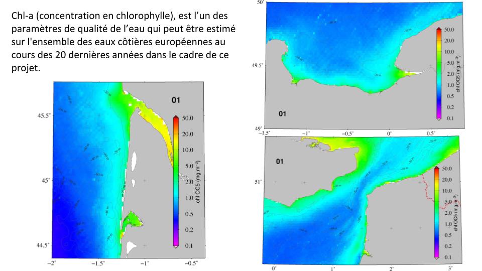
Monitoring and assessing the evolution of coastal waters is fundamental to identifying areas where significant changes are occurring, so as to prioritize appropriate actions for their preservation. In this context, satellite observation of the ocean now makes it possible to collect a range of physical and biological parameters on spatiotemporal scales inaccessible to traditional in situ measurements. Among the various parameters that can be observed from space, the measurement of water color provides qualitative and quantitative information on the biogeochemical composition of surface waters.
GOALS
Using spatial remote sensing to assess and analyze the quality of Europe’s coastal waters
METHOD
Against this backdrop, the Coastal Ocean Watch project, involving researchers and engineers in remote sensing and ecology, has been developed around one main objective:
Assessing and analyzing temporal changes in the quality of European coastal waters over the past 20 years using spatial remote sensing of water color.
To do this, we will use appropriate algorithms coupled with satellite observations to estimate certain biogeochemical parameters, providing relevant information on the water quality and trophic status of European coastal waters. The time series of these various marine parameters will then be analyzed using appropriate statistical tools to define their main temporal trends over the last 20 years. As the preservation of marine biodiversity is closely linked to environmental monitoring, this project will provide essential information to decision-makers so that they can take appropriate measures to stabilize and/or enhance natural biodiversity.
Results and advances
Coming soon
Step 1
Lorem ipsum dolor sit amet, consectetur adipiscing elit. Ut elit tellus, luctus nec ullamcorper mattis, pulvinar dapibus leo.
Lorem ipsum dolor sit amet, consectetur adipiscing elit. Ut elit tellus, luctus nec ullamcorper mattis, pulvinar dapibus leo.
étape 2
Lorem ipsum dolor sit amet, consectetur adipiscing elit. Ut elit tellus, luctus nec ullamcorper mattis, pulvinar dapibus leo.
Lorem ipsum dolor sit amet, consectetur adipiscing elit. Ut elit tellus, luctus nec ullamcorper mattis, pulvinar dapibus leo.
étape 3
Lorem ipsum dolor sit amet, consectetur adipiscing elit. Ut elit tellus, luctus nec ullamcorper mattis, pulvinar dapibus leo.
Lorem ipsum dolor sit amet, consectetur adipiscing elit. Ut elit tellus, luctus nec ullamcorper mattis, pulvinar dapibus leo.
The team
Hubert Loisel
Laboratoire d'Océanologie et de Géosciences, affiliated with Université Littoral-Côte d'Opale, Centre National Français de Recherche Scientifique, and Université de Lille
Partners
Scientific partners
Université Littoral-Côte d'Opale
Technical partners
LOG ACRI
Institutional Partners
First name Last name
Université, structure, asso,...
First name Last name
Université, structure, asso,...
First name Last name
Université, structure, asso,...