[av_one_full first min_height=” vertical_alignment=” space=” custom_margin=” margin=’0px’ padding=’0px’ border=” border_color=” radius=’0px’ background_color=” src=” background_position=’top left’ background_repeat=’no-repeat’ animation=” mobile_breaking=” mobile_display=”]
[av_textblock size=” font_color=” color=” av-medium-font-size=” av-small-font-size=” av-mini-font-size=” admin_preview_bg=”]
News from the research expedition to map unprotected coralligenous habitats in the Aegean sea!
[/av_textblock]
[/av_one_full]
[av_one_half first min_height=” vertical_alignment=” space=” custom_margin=” margin=’0px’ padding=’0px’ border=” border_color=” radius=’0px’ background_color=” src=” background_position=’top left’ background_repeat=’no-repeat’ animation=” mobile_breaking=” mobile_display=”]
[av_textblock size=” font_color=” color=” av-medium-font-size=” av-small-font-size=” av-mini-font-size=” admin_preview_bg=”]
[/av_textblock]
[/av_one_half]
[av_one_half min_height=” vertical_alignment=” space=” custom_margin=” margin=’0px’ padding=’0px’ border=” border_color=” radius=’0px’ background_color=” src=” background_position=’top left’ background_repeat=’no-repeat’ animation=” mobile_breaking=” mobile_display=”]
[av_textblock size=” font_color=” color=” av-medium-font-size=” av-small-font-size=” av-mini-font-size=” admin_preview_bg=”]
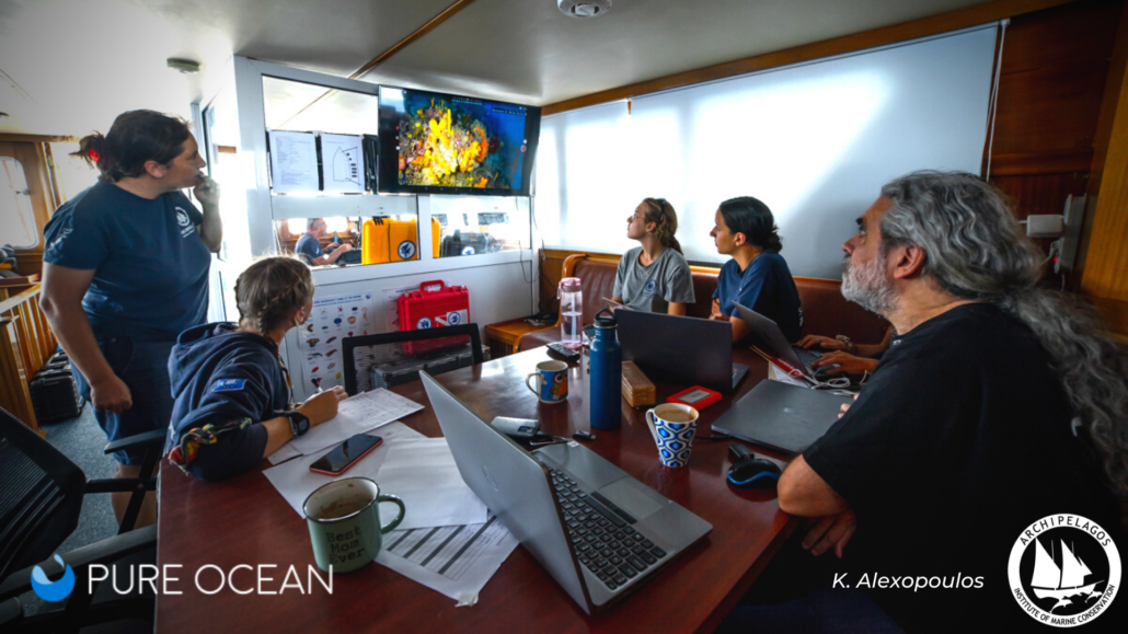
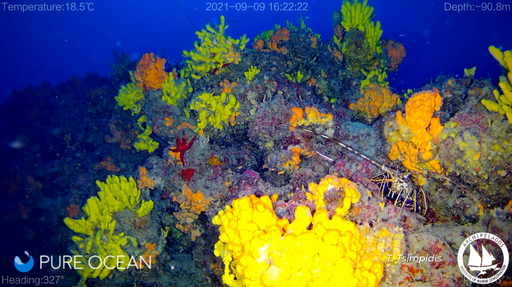
In 2021, the Archipelagos Institute of Marine Conservation completed a 14-day expedition to the Fourni Archipelago in the Aegean Sea, Greece. The expedition aimed to map, document and collect data on one of the most fragile habitats in the Mediterranean Sea: Coralligenous habitats. Considered the “best-kept secret of the Mediterranean”, these key ecosystems are rarely studied, despite their great conservation value and incredible beauty. They are largely unknown to the general public and face increasing anthropogenic destruction, mainly by bottom trawling damage.
The expedition aimed to acquire important preliminary data about the distribution of unstudied and unmapped coralligenous habitats, while expanding the current knowledge of biodiversity, taxonomy and vulnerability of these ecosystems in the Aegean. Additionally, the pilot mapping will be used to urge full enforcement of the existing regulations at (inter)national levels. Our goal is the establishment of no-trawling zones to halt the ongoing destruction of these productive and highly important marine ecosystems before it is too late.
[/av_textblock]
[/av_one_half]
[av_one_half first min_height=” vertical_alignment=” space=” custom_margin=” margin=’0px’ padding=’0px’ border=” border_color=” radius=’0px’ background_color=” src=” background_position=’top left’ background_repeat=’no-repeat’ animation=” mobile_breaking=” mobile_display=”]
[av_textblock size=” font_color=” color=” av-medium-font-size=” av-small-font-size=” av-mini-font-size=” admin_preview_bg=”]
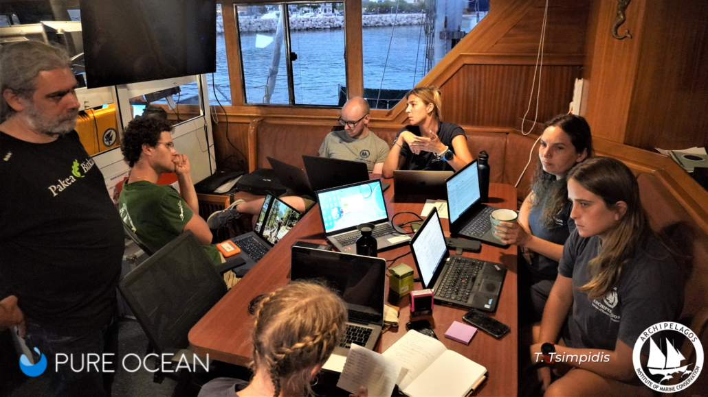
Accurate maps are a key prerequisite for the effective management and conservation of coralligenous habitats. To produce maps of coralligenous distribution, the active role of local fishermen is invaluable. For almost 15 years now, Archipelagos Institute and local fishing communities have developed a relationship of mutual trust, exchanging knowledge of the sea. Together, we aim to halt the ongoing destruction of these productive marine ecosystems before it is too late. When docked at small islands, the evenings provided time for extensive engagement with local fishermen to share existing and recently gathered knowledge to produce preliminary maps of coralligenous distribution.
[/av_textblock]
[/av_one_half][av_one_half min_height=” vertical_alignment=” space=” custom_margin=” margin=’0px’ padding=’0px’ border=” border_color=” radius=’0px’ background_color=” src=” background_position=’top left’ background_repeat=’no-repeat’ animation=” mobile_breaking=” mobile_display=”]
[av_textblock size=” font_color=” color=” av-medium-font-size=” av-small-font-size=” av-mini-font-size=” admin_preview_bg=”]
[/av_textblock]
[/av_one_half]
[av_one_half first min_height=” vertical_alignment=” space=” custom_margin=” margin=’0px’ padding=’0px’ border=” border_color=” radius=’0px’ background_color=” src=” background_position=’top left’ background_repeat=’no-repeat’ animation=” mobile_breaking=” mobile_display=”]
[av_textblock size=” font_color=” color=” av-medium-font-size=” av-small-font-size=” av-mini-font-size=” admin_preview_bg=”]
[/av_textblock]
[/av_one_half]
[av_one_half min_height=” vertical_alignment=” space=” custom_margin=” margin=’0px’ padding=’0px’ border=” border_color=” radius=’0px’ background_color=” src=” background_position=’top left’ background_repeat=’no-repeat’ animation=” mobile_breaking=” mobile_display=”]
[av_textblock size=” font_color=” color=” av-medium-font-size=” av-small-font-size=” av-mini-font-size=” admin_preview_bg=”]
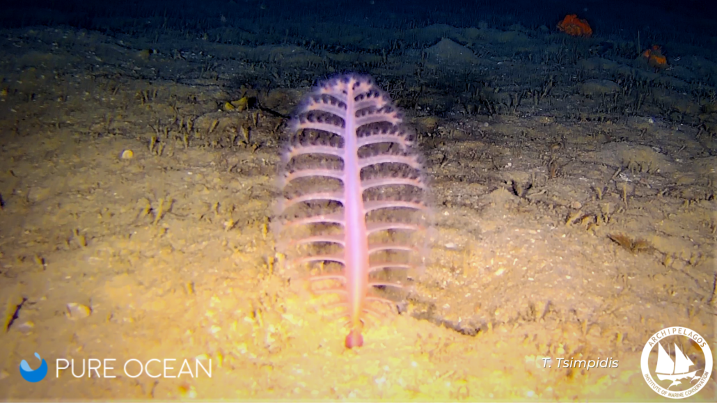
As a result of the efforts from the Aegean Explorer research vessel crew and the local fishermen, the project documented multiple interesting habitats near the Fourni Archipelago. In a marine area of just 7000m2, the international team onboard identified over 250 marine flora and fauna species, in the mesophotic zone (at about 100m depth). One of the most interesting species, the Phosphorescent sea pen (Pennatula phosphorea), formed beautiful “underwater gardens” in our research area. Unfortunately, Pennatula phosphorea is listed by the IUCN Red List as a “vulnerable species” with a decreasing population. Their distribution around the Aegean Sea remains unknown, making them extremely susceptible to bottom trawling and other human impacts.
[/av_textblock]
[/av_one_half][av_one_half first min_height=” vertical_alignment=” space=” custom_margin=” margin=’0px’ padding=’0px’ border=” border_color=” radius=’0px’ background_color=” src=” background_position=’top left’ background_repeat=’no-repeat’ animation=” mobile_breaking=” mobile_display=”]
[av_textblock size=” font_color=” color=” av-medium-font-size=” av-small-font-size=” av-mini-font-size=” admin_preview_bg=”]
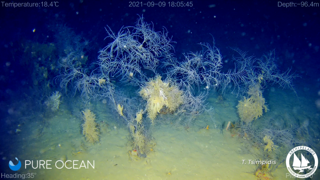
Another interesting finding was the localisation of a previously undiscovered extensive black coral “forest” at a depth of 100m. Black coral forests form habitats crucial for many other marine species (i.e. sharks, rays, squids, etc.) who lay their eggs within the forests. The black coral is a protected species, which is also threatened by trawlers. According to Greek legislation, the operation of towed-gear trawling is not restricted in the area where this black coral forest was located. Trawling continues as long as the Greek authorities have not mapped these protected marine habitats up to this day. Consequently, this black coral forest faces a constant risk of irreversible destruction.
[/av_textblock]
[/av_one_half][av_one_half min_height=” vertical_alignment=” space=” custom_margin=” margin=’0px’ padding=’0px’ border=” border_color=” radius=’0px’ background_color=” src=” background_position=’top left’ background_repeat=’no-repeat’ animation=” mobile_breaking=” mobile_display=”]
[av_textblock size=” font_color=” color=” av-medium-font-size=” av-small-font-size=” av-mini-font-size=” admin_preview_bg=”]
[/av_textblock]
[/av_one_half]
[av_one_half first min_height=” vertical_alignment=” space=” custom_margin=” margin=’0px’ padding=’0px’ border=” border_color=” radius=’0px’ background_color=” src=” background_position=’top left’ background_repeat=’no-repeat’ animation=” mobile_breaking=” mobile_display=”]
[av_textblock size=” font_color=” color=” av-medium-font-size=” av-small-font-size=” av-mini-font-size=” admin_preview_bg=”]
[/av_textblock]
[/av_one_half]
[av_one_half min_height=” vertical_alignment=” space=” custom_margin=” margin=’0px’ padding=’0px’ border=” border_color=” radius=’0px’ background_color=” src=” background_position=’top left’ background_repeat=’no-repeat’ animation=” mobile_breaking=” mobile_display=”]
[av_textblock size=” font_color=” color=” av-medium-font-size=” av-small-font-size=” av-mini-font-size=” admin_preview_bg=”]
The ultimate aim of the long-term project ‘Protecting Aegean Coralligene’ is to address the largest threat faced by these essential habitats and the need for immediate enforcement of the existing legislation to prohibit towed trawling gear. With this implemented, the survival of these biodiversity hotspots will be ensured for future generations. Above all, the research consortium focuses on the Fourni Archipelagos and on a Mediterranean-wide scale. With the support of the Pure Ocean Fund, Archipelagos – Institute of Marine Conservation and our partners, Oceana, the School of Life Sciences department of the University of Essex, the United Nations Regional Action Center for the Mediterranean (UNEP / MAP – SPA RAC) and the Laboratory of Physical Geography of the National and Kapodistrian University of Athens, were able to begin mapping the distribution of these valuable habitats in the Aegean Sea and other regions of the NE Mediterranean. The consortium will continue with the legislation aspects to ensure the protection of the preliminary mapped areas in the coming year.
[/av_textblock]
[/av_one_half][av_one_full first min_height=” vertical_alignment=” space=” custom_margin=” margin=’0px’ padding=’0px’ border=” border_color=” radius=’0px’ background_color=” src=” background_position=’top left’ background_repeat=’no-repeat’ animation=” mobile_breaking=” mobile_display=”]
[av_textblock size=” font_color=” color=” av-medium-font-size=” av-small-font-size=” av-mini-font-size=” admin_preview_bg=”]
Tim Grandjean, Anastasia Miliou, Alice Malcolm-McKay de l’Institut Archipelagos for Marine Conservation.
[/av_textblock]
[av_image src=’https://www.pure-ocean.org/wp-content/uploads/2022/03/website-logo.png’ attachment=’8252′ attachment_size=’full’ align=’center’ styling=” hover=” link=” target=” caption=” font_size=” appearance=” overlay_opacity=’0.4′ overlay_color=’#000000′ overlay_text_color=’#ffffff’ animation=’no-animation’ admin_preview_bg=”][/av_image]
[/av_one_full]