3D mapping and monitoring of vulnerable Mediterranean habitats using structure-from-motion photogrammetry.
THE 3d-4-SEAC project
CONTEXT AND MAIN ISSUES
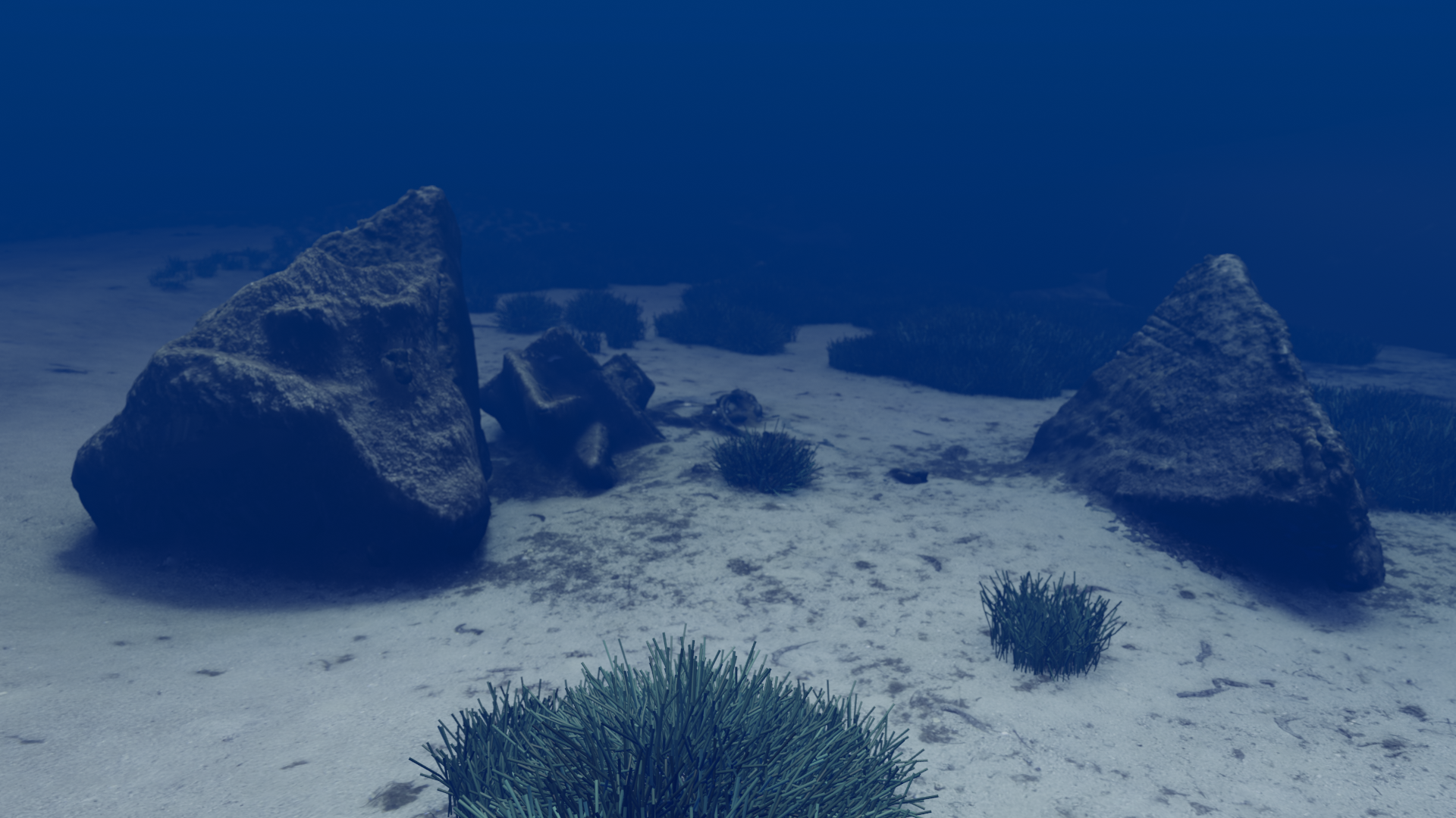
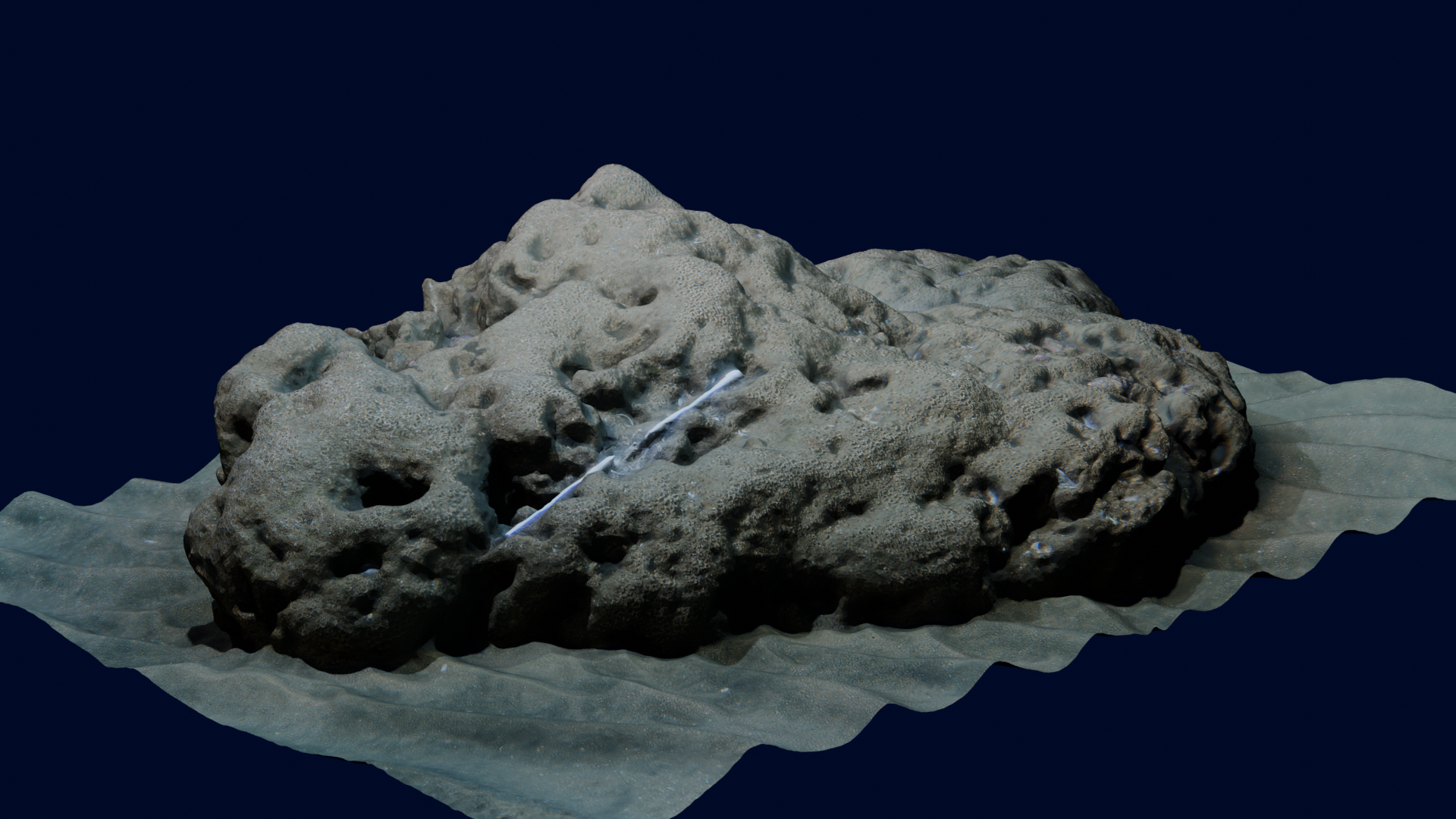
Some coastal ecosystems are of remarkable ecological importance, hosting a vast diversity of species for all or part of their existence. Today, however, they are under direct pressure from coastal human activities and climate change. In the Mediterranean Sea, these key habitats include Posidonia meadows, as well as coralligenous habitats and hermella beds. These biogenic underwater structures are the result of simultaneous construction and destruction by a wide variety of organisms. Monitoring the dynamics of the volume and morphology of these reefs is therefore a powerful indicator of the state of the living communities that make them up.
GOALS
3D mapping and monitoring of vulnerable Mediterranean habitats using structure-from-motion photogrammetry.
METHOD
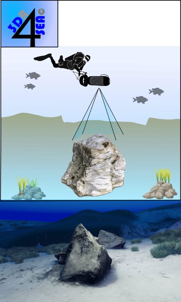
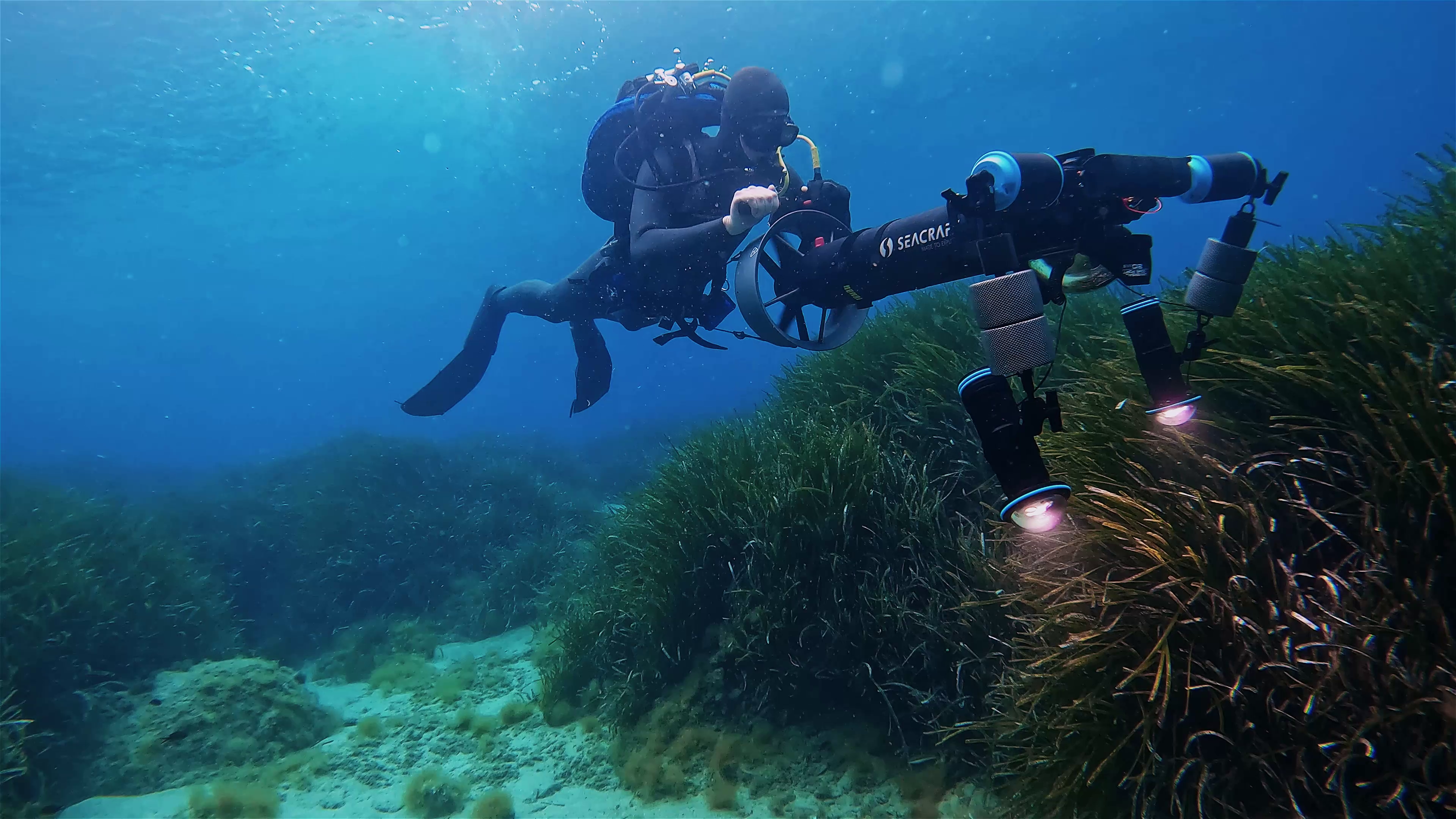
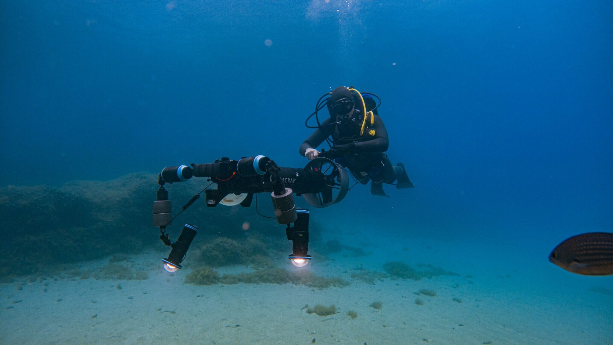
Unlike conventional surveys, structure-from-motion photogrammetry is a rapid, non-invasive, unbiased imaging technique that can effectively map the relief of these habitats. Like our 2 eyes, 2 synchronized cameras are used to capture stereoscopic images, which are then computer-processed to produce a high-resolution 3D model of the habitats explored by the diver.
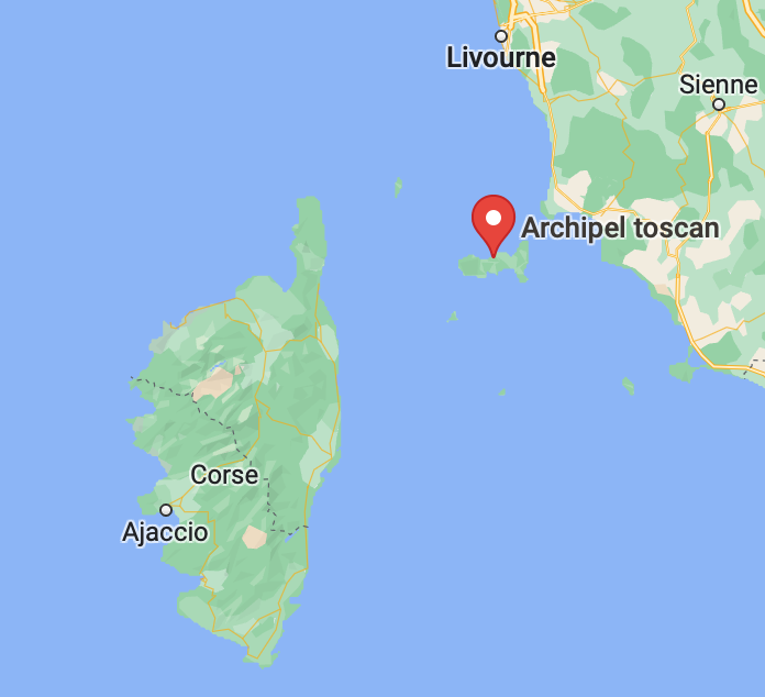
The “3D-4-SEAC” (3D for SEA Conservation) project focuses on key habitats along the coast of Lazio and the Tuscan archipelago in Italy. It will provide a better understanding of the interactions between the topology of the sites and the biological communities that thrive there, and their fine-scale evolution – valuable data for the possible specific protection of these areas. In addition, the visualizations produced by the 3D models can be used as a cross-disciplinary tool for a wide range of research topics, as well as a means of raising public awareness through video “virtual dives”.
HOW IS THIS PROJECT INNOVATIVE?
The 3D-4-SEAC project uses structure-from-motion photogrammetry to map key habitats along the coast of Lazio and the Tuscan archipelago in Italy. This rapid, non-invasive and unbiased imaging technique is used to create high-resolution 3D models of underwater habitats, providing valuable data on the interactions between the topology of sites and the biological communities that develop there. The 3D visualisations can also be used as a cross-disciplinary research tool and as a means of raising public awareness during video ‘virtual dives’. In short, 3D-4-SEAC offers a new approach to better understanding and protecting coastal ecosystems threatened by human activities and climate change.
LOCATION
Graphic summary


NEWS
Project duration
2022 – 2024
SUSTAINABLE DEVELOPMENT GOALS
Results and advances
Coming soon
Step 1
Lorem ipsum dolor sit amet, consectetur adipiscing elit. Ut elit tellus, luctus nec ullamcorper mattis, pulvinar dapibus leo.
Lorem ipsum dolor sit amet, consectetur adipiscing elit. Ut elit tellus, luctus nec ullamcorper mattis, pulvinar dapibus leo.
étape 2
Lorem ipsum dolor sit amet, consectetur adipiscing elit. Ut elit tellus, luctus nec ullamcorper mattis, pulvinar dapibus leo.
Lorem ipsum dolor sit amet, consectetur adipiscing elit. Ut elit tellus, luctus nec ullamcorper mattis, pulvinar dapibus leo.
étape 3
Lorem ipsum dolor sit amet, consectetur adipiscing elit. Ut elit tellus, luctus nec ullamcorper mattis, pulvinar dapibus leo.
Lorem ipsum dolor sit amet, consectetur adipiscing elit. Ut elit tellus, luctus nec ullamcorper mattis, pulvinar dapibus leo.
The team

Dr. Daniele Ventura
Post-doctoral fellow in Environmental Biology at the University of Rome ‘La Sapienza’.
Luca Castoro
Développeur logicSenior Software Developeriel senior
Dr. Edoardo Casoli
Post-doctorPost-doctoral fellow in Environmental Biology at the University of Rome ‘La Sapienza’.ant en Biologie Environnementale à University of Rome ‘La Sapienza’
Gianluca Mancini
DoctorantDoctoral student in Environmental Biology at the University of Rome ‘La Sapienza’. en Biologie Environnementale à University of Rome ‘La Sapienza’
Partners
Prof. Giandomenico Ardizzone
Professor of Marine Ecology at the University of Rome Ecologie Marine à University of Rome
Dr. Andrea Belluscio
Research technician at University of Romeherche à University of Rome
Dr. Daniela Sylvia Pace
Post-doctoral fellow in Environmental Biology at the University of Rome